Who: I’m David M. Boje, Ph.D., Emeritus Regents Professor New Mexico State University, Professor Aalborg University Denmark, ad co-founder of True Storytelling Institute (https://truestorytelling.org). My expertise in in public-private organization studies. I have 28 books and 150 articles about how to do inter-agency collaboration.

I live at 4700 Dunn Drive, across to the West of State Land Office Parcel. My on line vita is at https://davidboje.com/vita
MWHAT ARE MAIN PBOBLEMS TO SOLVE IN EAST MESA?
This is part of presentation to City of Las Cruces Planning and Zoning Commission meeting July 27 2021 Click Here to see the slides
Some key issues to solve in East Mesa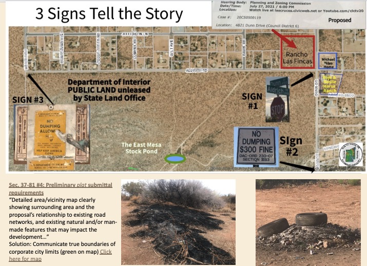
A few excepts (links are in above slide set)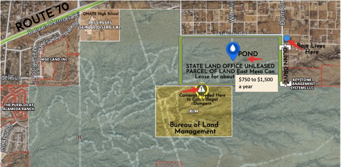


This is part of presentation to City of Las Cruces Planning and Zoning Commission meeting July 27 2021 Click Here to see the slides
Here is a 4 minute video of 7 Problems that need to be addressed in East Mesa before granting waivers for environmental study and for roads.
Three Signs in the East Mesa tell a “True Storytelling” of the Problem and Reveal the Solution that Inter-Agency Sign-Coordination could resolve.

The story three signs tell, is Aldrich and Dunn cannot afford waivers to plat (environmental study) and road requirements because the signs already on Dunn & Aldridge are placed errantly.

Sign # 1 STOP SIGN, 1 of 4 to go on the 4 corners of DUNN Dr. and Aldridge Rd., is an Interrupted and Stalled Project
THE STOP SIGN CONFLICT OF PLACEMENT. Sign #1 is the City’s installed STOP SIGN on the southwest corner of Dunn Dr. and Aldridge Road. The City of Las Cruces STOP SIGN is wrongly placed. It should be relocated to the the southeast corner, allowing the City of Las Cruces to put its own STOP SIGNS on the northwest and northeast corners. In point of fact, the southwest corner STOP SIGN in on the Department of Interior Public Land, currently unleased parcel administered by New Mexico State Land Office.

Doña Ana County says, the northeast corner street sign is installed, and once installed, it cannot be relocated. Nor can the City hang a City STOP SIGN on a post that belongs to Doña Ana County. Stalemate. End of story.
However, there are consequences fo City and Doña Ana County residents of having only the one STOP SIGN on only just one of the four corners. The traffic heading southbound on Dunn Dr. is loosing bumpers and undercarriages. Dunn and Aldridge have frequent after mid-night drag racing going on. Posted speed on Aldrich is 30 MPH and on Dunn its 35 MPH. In short not having proper signage is a road hazard. The East-West and the North-South traffic, has on-going illegal drag strip racing on the paved portions. Michael Telles, goes out with a spotlight to get them to cease and desist. Michael and I also collect the weekly accumulation of bumpers and undercarriage, plus the usual beer and liquor bottle and can-litter along Dunn and Aldridge from driving under the influence.
What are the City of Las Cruces Relevant Ordinance for SIGN #1
Code of Ordinances Chapter 27 – TRAFFIC ARTICLE VI. – TRAFFIC REGULATIONS
| Sec. 27-12-6-3.2. – Authority to erect stop and yield signs at through streets. |
A.
| Whenever the administrator designates and describes a through street, the city traffic engineer shall place and maintain a stop sign, or on the basis of an engineering and traffic investigation at any intersection a yield sign, on each and every street intersecting the through street unless traffic at any such intersection is controlled at all times by traffic-control signals. https://library.municode.com/nm/las_cruces/codes/code_of_ordinances?nodeId=PTIIMUCO_CH27TR_ARTVITRRE_S27-12-6-3.2AUERSTYISITHST |
B.
| However, at the intersection of two through streets or at the intersection of a through street and heavy traffic street not so designated, stop signs shall be erected at the approaches to both of said streets in a manner determined by the administrator upon the basis of an engineering and traffic study. |
(Ord. No. 2121, § VI, 7-19-04).
What about the County Ordinances concerning Stop Signs?
SEE A DANGER TO PUBLIC SAFETY? REPORT IT!
July 27, 2010
During the public input period of today’s meeting of the Doña Ana County Board of Commissioners, a concerned resident asked what number to call if he saw a downed stop sign or other threat to public safety.
Residents can call the Mesilla Valley Regional Dispatch Authority’s non-emergency number, (575) 526-0795, to report threats to public safety. The MVRDA staff has on-call numbers for county and city personnel, and they will dispatch the appropriate personnel and equipment 24/7. https://www.donaanacounty.org/node/136180
For more information, please contact the Doña Ana County Codes Enforcement Department at (575) 525-8846.
For more information about Doña Ana County, please visit www.donaanacounty.org.

Sign # 2 ‘No Dumping’ in Doña Ana County
There is a reason why Doña Ana County has only one ‘No Dumping’ sign along Aldridge Rd. and Dunn Dr. We moved to 4700 Dunn Drive about 17 years ago. There was a a barbed wire fence with posts, south of Aldridge Rd. all the way to Alameda Arroyo. Over the years, motorists trying to not get stuck-in-the-mud during the monsoon flooding, drove around the west side of the barbed wire fencing, and began to cut the fence, and remove the posts. This had the consequence of appropriating the county’s land where signs could be located. You see the County cannot put a sign onto the Department of Interior’s land parcel, and over the years, where Sign #2 is located, is about the only place they can located it. I know, because I offered to buy No Dumping Signs, and County codes was going to put them along Dunn Drive, but found out its land was intruded upon by automobile traffic. So that is the story of why there is on sign, and so out of the way of where people in off-road vehicles enter the Department of Interior’s Public Lands to do their illegal dumping, the sign has zero effect on resident comportment.
Where do off-roaders go to recreate illegally, and to dump? They are crossing Aldridge at the Wilt Ave. and Davis Rd locations, and entering those trails, that with the excess vehicle traffic are now illegal roads. Should someone lease the Public Land parcel, the leasee would be responsible to close down the two illegal roadways, and return them to their natural state, as game trails. I know because I was going to have such a lease, for about $750 a year for first five years, plus my expense of re-installing barbed wire fence, replanting damaged ares from illegal off road motor vehicle traffic, planting trees etc. and attending to the removal of illegal dumping, mainly at the Stock Pond. It would require in excess of $200,000 to accomplish. A worthy project, that perhaps Sierra Club, or some other Wilderness group could undertake.

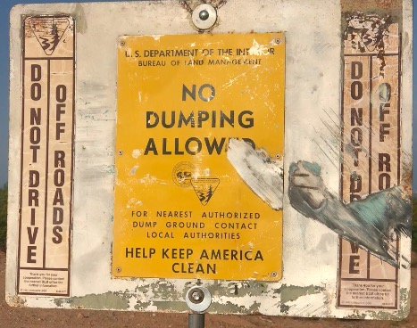
Sign # 3 Dept of Interior BLM – No Dumping or Off-Road-Motoring Allowed
Sign # 3 suffers the same mis-location of the sign as Signs #1 and #2. To reiterate, the main traffic pattern of off-roaders, illegally entering Public Land by going on game trails, or just driving over vegetation, is where Wilt Ave. and Davis Rd. cross Aldrich Rd., southbound, heading to the favored dumping site, the Stock Pond. Several problems are apparent. First, this is not BLM parcel, its a New Mexico State Land Office Parcel. The BLM parcel is further south, where the Billy The Kid cave and hideout are located (see film below). Most residents assume the Public Land is all BLM land, but that is not really true. Second, is the location of the sign. There has been no sign for many years(as long as I lived at Dunn Dr.), and this new sign, is a valiant, low-budget attempt at signage. A more rational location would be at Wilt and Davis crossways. Third, since residents and visitors do not know the regulations about either BLM or NM State Land Office Land, there is widespread ‘bewilderment.’ Public Land has regulations by BLM, State Land Office, Fish and Game, and so on. But, since residents see no signs posted, and do not really know what are the specific regulations, they make them up as suits their wants and desires.

There, in point of fact, are 17 pertinent Public Land regulations, that apply. One of these is you have to have either a BLM/SLO recreation permit which costs $35 a year, or a hunting license (in hunting season) and neither of these allows for dumping, buring fires (or fireworks) or driving off-road vehicles off the official roads (there are no official roads crossing Aldrich). If residents knew permit is required, they might just comply.
Here is my permit:

This next YouTube is about 8 minutes, and makes some good points about what Nature’s creatures are Smarter than Human Creatures, especially city, counter, state, and federal governing agencies, who could just sit down, learn each other’s regulations and then cooperate for the benefit of residents and nature, including the toads.
Summary:
People are supposed to be the rational animals. Then, why are New Mexico Spadefoot Toads more rational that city, state, county, and federal agencies? How rational are these toads? They live in the arid desert where there is only the monsoon rains, this time of year to fill some stock ponds where I live in the East Mesa. Until the monsoons, they hibernate, then hearing the and feeling the thunder, the dig up about a foot or so to the surface, and hope they got it right, and water exists in the ephemeral stock pond. This year a lot of thunder and lightning but not so much water. Not yet. Without freshwater, the mating spadefoot’s offspring tadpoles won’t survive. Here is the rational bit. If conditions are bleak, the parents have carnivore tadpoles. In favorable conditions, more omnivore tadpoles. If the spadefoots misread the signs, say, mistaking off-road vehicles illegal travel through the pond bed, then they could expend last energy digging to the surface, and no water. How does this compare to the rational decision making behavior of government agencies? Agencies are not able to coordinate across silos, and read the signs of the times. The film tells the story of a street sign Dona Ana County installed on the wrong corner of an intersection (the City’s corner), but now the County refuses to move a sign once installed. The City won’t put a sign on the County’s side of the intersection. It gets more irrational. The Dona Ana County only illegal dumping sign is down past the end of the unpaved section of Dunn Drive. And no where else along the South of Aldridge public land. Why? Because only the State Land Office of New Mexico, who is the agency for the parcel of land South of Aldridge can locate a sign there. Result, there is only one no dumping County sign, and its in the place least traveled by illegal dumpers. Dumpers are never caught because, you have to catch them in the act, not after they flee the scene. It gets more irrational. After many films and calls, and on-site and Zoom meetings, the State Land Office of New Mexico put their No Dumping sign, just one. Like the County the sign (at Porter & Dunn) is in the least likely location to get the attention of the off-road vehicle traffic bringing (sometimes) illegal dumping to the stock pond or Alameda Arroyo where partiers go the the Las Cruces dam. It gets more problematic. The Sign says Department of Interior (Bureau of Land Management), but the parcel is actually that of NM State Land Office (SLO). SLO leases mining, cattle grazing, recreation, and is ready to sell parcel to whatever next developer has the cash. Developers know how the game is played, and wait for the land to deteriorate with trash and denuded vegetation, then pick it up without much fuss. It gets worse and worse. With these two no dumping signs, in errant locations, the residents don’t know what is going on. Who has jurisdiction? Is it the city, county, state, and which federal agency? Is it legal to drive off road vehicles on the trails from Davis Rd or Wilt Ave into Public Land? Actually it’s not legal, but without signs, everyone either assumes its legal or ignores the government regulations. Is it legal to set fire to trees, or have burn the illegal dumping and have a tailgate at the pond while shooting automatic pistols, rifles and more than a few machine guns? None of this is legal on Public Land. You have to have a $35recreation permit or current hunting license (& be hunting) to set foot on it. I guess you see the problem of growing illegal East Mesa behavior. The spadefoot toads are the only ones not confused. They hibernate until the monsoon thunder, then they dig to the surface. If there is sufficient freshwater, they breed. If conditions worsen, more carnivore tadpoles. An ephemeral pond has no fish, otherwise the game of life cannot be played. The New Mexico Fairy shrimp are also smarter than government agencies. They hatch cysts (like eggs) that ly dormant, and won’t issue forth the orange color shrimp every season. If they did, the birds are smart enough to figure out the game, and would eat all the shrimp. No survival. The solution to inter-agency cooperation and coordination is to get together and share their stories, learn from each other, and engage in give and take. All the problems of the East Mesa could be solved in a few sessions, and with some marketing campaigns to let neighbors and off road vehicle and gun owners know the rules.
Why I oppose at this time: Let me state, I lived in mobil home estate while attending Buriington College, in Browns Mills, NJ. It was a great experience, because someone ran the mobile home estate, and there were rules: skirting around each mobile home, no junk in the yard, a fence around the place.
My concern is are their such rules be in place before the Rancho Las Fincas decision by Las Cruces City Councils?
Currently there are over 24 mobile homes (single or double wide) and four site0built homes between Porter and Dunn. To add more single subdivided mobile homes, seem unwise decision at this time.
There are 7 major problems in East Mesa that can be resolved with inter-agency coordination and public input before making this decision.
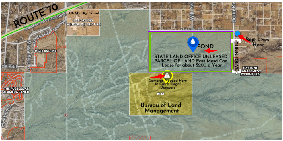
These 7 problems are relevant to the July 27 2021 6PM Planning and Zoning Commission meeting (Case 2-CS0500119. The decision for City of Las Cruces approval of plat and road waiver for 8-l0t single family mobile homes subdivision of 9.357 acres zoned Residential Estate Mobil, located 4821 Dunn Drive, at northwest corner of Dunn Drive and Aldridge Road. Aldridge Road is currently on the border between agency-jurisdictions, and is used as an evening, illegal drag strip and as illegal entry of off-road vehicles into Public Land, some of whom engage in illegal dumping, and set fires at the stock pond. Here is a map of the area showing
Parcel r0219360 is owned by Department of Interior allocation to New Mexico’s State Land Office not the Bureau of Land Management The parcel is all alnds South of Aldrich and West of Dunn. Two illegal access roads have been worn in by off-road motor vehicle traffic entering the parcel at Aldridge crossing at end of City’s Wilt Ave and David Rd.
https://gis.donaanacounty.org/parcels/

The decision to approve a preliminary plat and road waiver without a proper and detailed plat map goes against the spirit of City Planning Section 37-81 #4″
Sec. 37-81 #4: Preliminary plat submittal requirements
“Detailed area/vicinity map clearly showing surrounding area and the proposal’s relationship to existing road networks, and existing natural and/or man-made features that may impact the development. Detail must be sufficient for the subject property to be located in the field using the map”.
This is the map sent by City of Las Cruces to our mailbox:

This vicinity map is necessary, because it illustrates the level of resident’s and inter-agency confusion about signage and jurisdictions. The area in red box is proposed location of the Rancho Las Fincas 8-mobile home gated community at corner of Dunn Ave. and Aldrich Road. Here is my attempt at an annotated vicinity map, showing the few signs that currently exist.

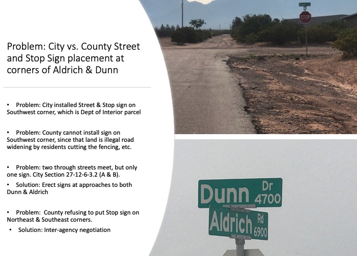
PROBLEM ONE: THE CITY AND COUNTY CAN NOT WORKOUT STOP SIGN LOCATIONS AT CORNER OF Dunn and Aldrich, the PROPOSED LOCATION of the “PLAT AND ROAD WAIVER” OF RANCHO LAS FINCAS Subdivision
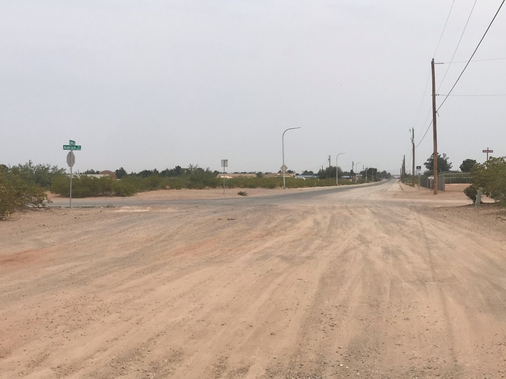
There is now a 4 way intersection with only one stop sign, for the East bound traffic. This is a dangerous intersection. The West bound does not have a corresponding stop sign. The reason is Aldrich Rd. is on the border of City and County jurisdictions. Each must put its own signs in its jurisdictional location. Add to this conflict the Department of Interior (State Land Office) land parcels are in Green, in the above map, on the South side of Aldridge Rd.

As the story goes: The County mistakingly put its stop sign on City property. The City asked the County to move it to the correct corner, and was refused. If the County were to relocate it to the County’s jurisdictional corner, it would allow the City to install its Stop sign, and then Aldridge west bound would also have a stop sign. Currently Dunn Drive North-bound and South-bound has no stop signs. This is dangerous, because after each monsoon rain, the unpaved road edge is pitted by the runoff, and cars loose their bumpers and undercarriages.
The unpaved County road begins as you Cross Aldridge on Dunn headed south-bound. This is also where the paved road of Aldridge ends in the City jurisdiction, and become un-maintained road Eastward to its end. The reason for City not to be able to maintain its own road, is an owner of a a Residential Estate Mobile (RE-M) is refusing the City of Las Cruces permission maintain the road or improve it with sidewalks etc.
Question: If the four corners of Dunn and Aldrich intersection cannot have inter-agency (City & County) coordination for stop sign location, then where will the road entrance and exit to the residential gaged community be located? This is reason one for refusing the approval of a preliminary plat and road waiver fo the 8-lot subdivision.
PROBLEM 2: Besides the Stop-Sign Jurisdictional Conflict, There is inadequate Illegal Dumping & Illegal Off-Road Motor Vehicle Signage, So the Public Land is Deteriorating
The City has no signage indication what is City and what is County jurisdiction of Illegal Dumping, and what is Department of Interior’s Public Land (administered by State Land Office in New Mexico or by the Bureau of Land Management County has one sign at end of Dunn Drive at edge of Alameda Arroyo ($300 fine illegal dumping) and Department of Interior has one sign at corner of Aldridge and Dunn (staying illegal dumping and off road motor vehicle is illegal). Neighbors as well as Police and Sheriff, do not know whether to call City or County Codes, or file public comment with State Land Office. The problem is the BLM does not have jurisdiction over the land parcel in Green, rather it is Department of Interior’s land given over to NM State Land Office, to sell leases (for cattle grazing, mining, or recreation, MORE at https://www.nmstatelands.org.
I renewed by NM State Land Office Recreational Access Permit, for $35.
PROBLEM 3: No one is permitted to walk or horse ride on land south of Aldrich (between Porter & Dunn)
Legal access requires either a State Land Office ‘Recreational Use Permit, $35 a year, or a Hunting permit from Fish and Game (only valid during hunting season.) Most all the residents do not know that access to Public Lind requires a Permit (hunting or recreational access).
According to SLO regulations and permits, 17 activities are absolutely PROHIBITED ACTIVITIES on this parcel:
- disturbing, harassing, injuring, destroying wildlife, livestock, or any other animal life;
- disturbing, dislodging, damaging, destroying or removing native plants, standing timber wood products, flowers, growing crops, or any other plant life other than pinon nuts gathered non-commercially
- 3. disturbing, dislodging, damaging, destroying or removing historical, archaeological, paleontological or cultural sites, or artifacts;
- disturbing, dislodging, defacing, damaging or destroying any improvement, fixture, item, object, or thing placed or located in, under, or upon the land;
- crossing lands not open to recreational access, without permission, to gain access to state trust lands that are open to recreational access;
- conducting off-road vehicle activities;
- bringing unrestrained (unleashed) animals on state trust lands;
- discarding refuse, waste, or litter of any kind;
- building open fires, igniting fireworks, or conducting any other activity that increases the risk of range, brush, or forest fires;
- conducting any type of commercial operations;
- discharging firearms, camping overnight, opening (without closing) gates;
- bringing onto state trust lands or consuming thereon any type of alcoholic beverage;
- violating any applicable law, statute, regulation, ordinance, or rule enacted by a governmental entity;
- fishing, trapping, or hunting without a valid New Mexico license;
- mineral exploration, development, or mining, or collecting valuable rocks or minerals;
- interfering with the authorized activities of other land users; or,
- entering, climbing, or accessing in any way structures, buildings, fixtures or improvements other than fences located on state trust land.
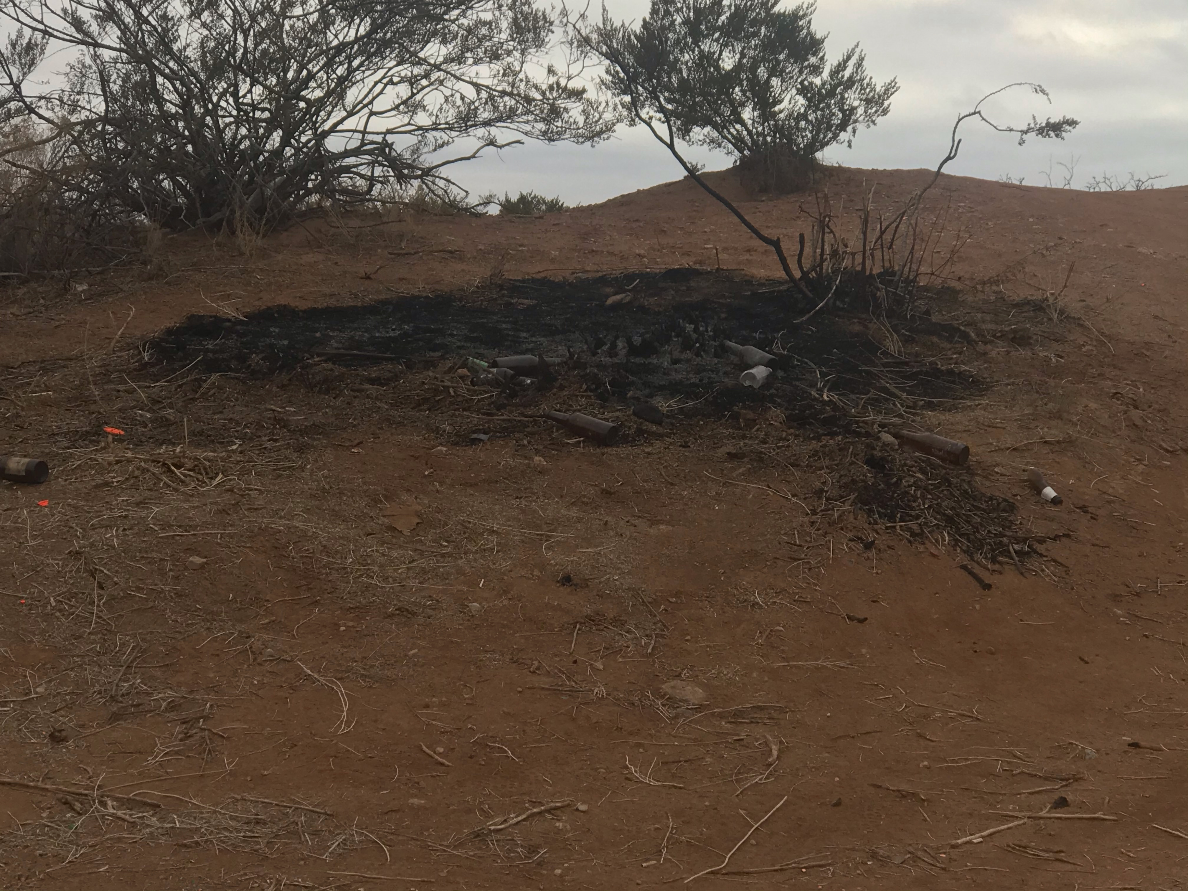
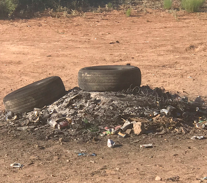
Photo taken Jan 20, 2021 of burning native plants (see regulation #2)
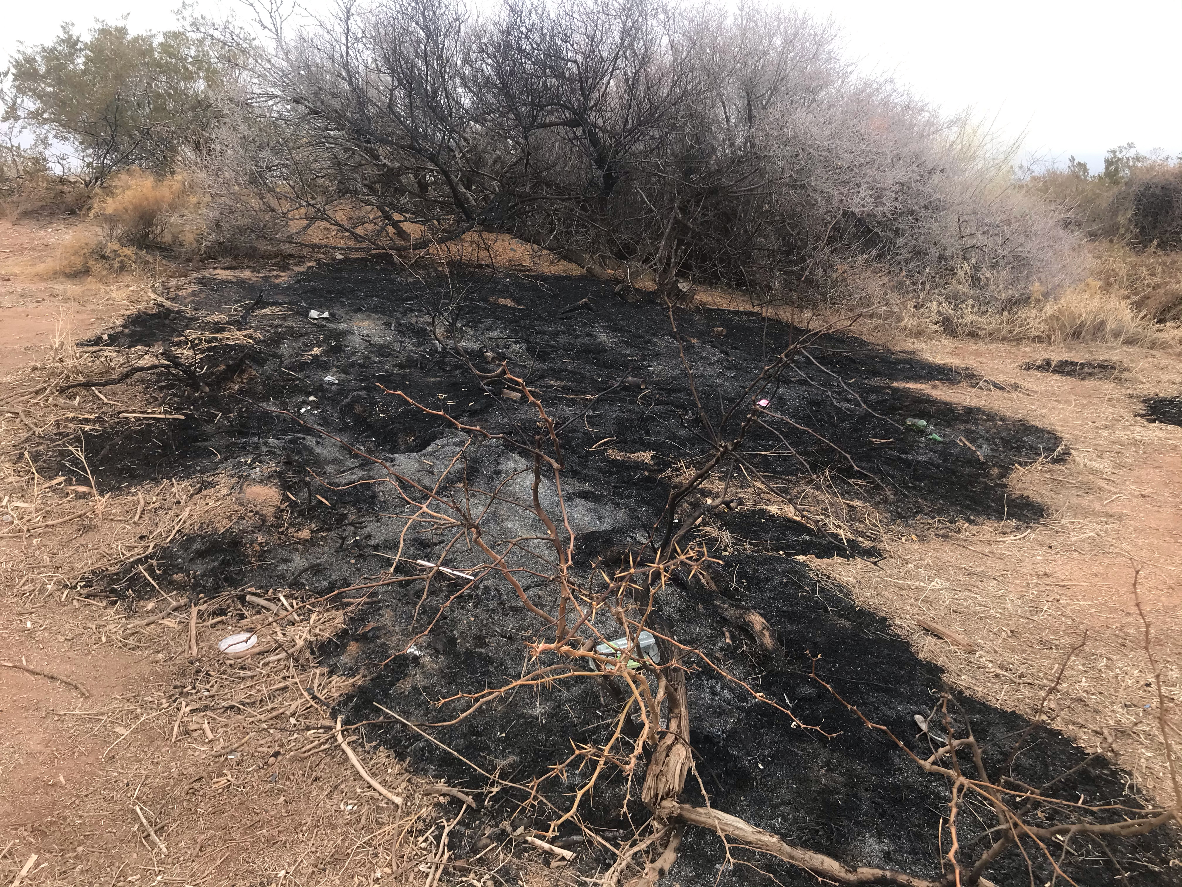
Photo taken Jan 20, 2021 of burning native plants (see regulation #2)
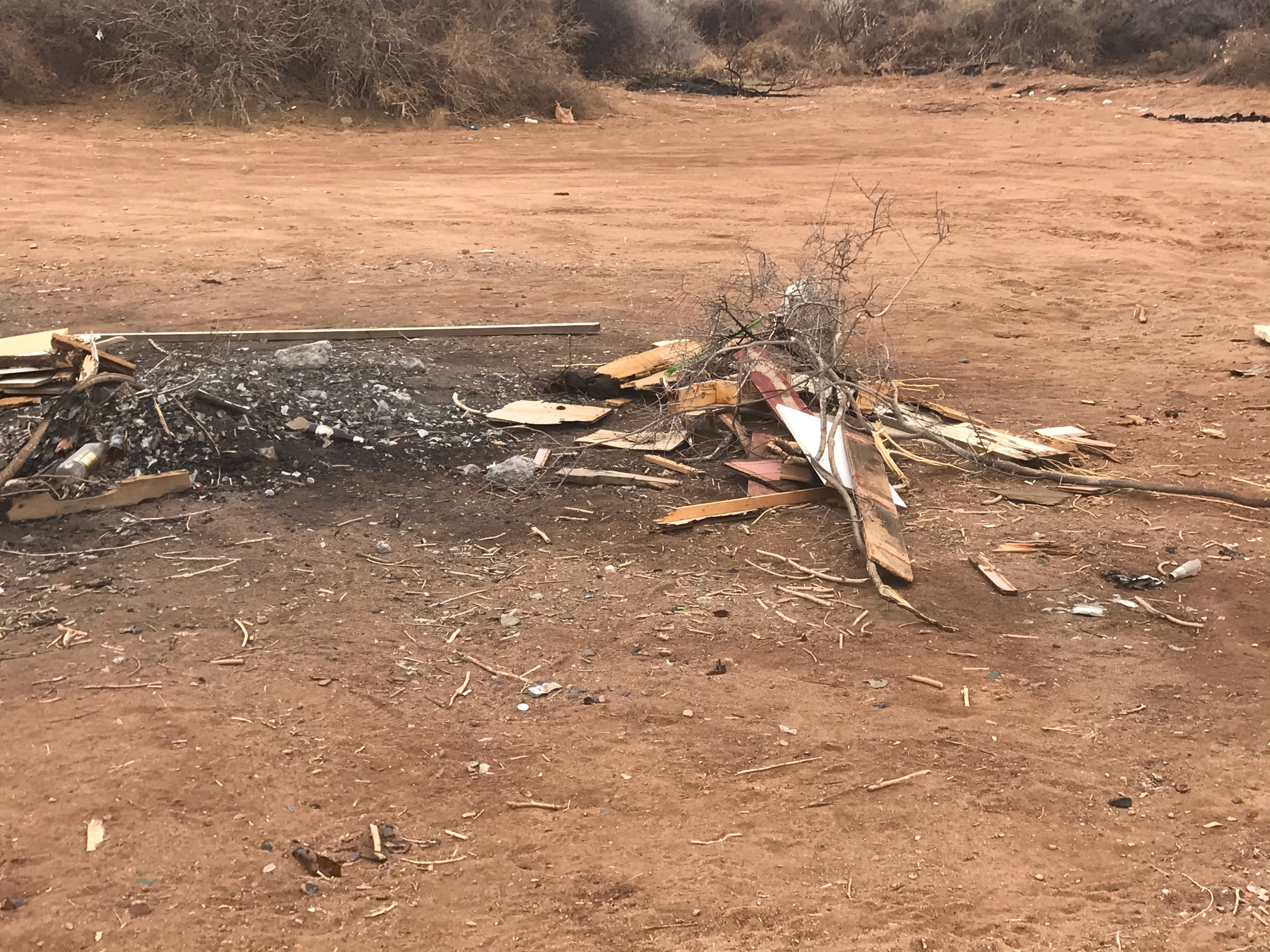
Photo taken Jan 20, 2021 of burning’ see Regs #8 and #9: discarding refuse, waste, or litter of any kind; building open fires, igniting fireworks, or conducting any other activity that increases the risk of range, brush, or forest fires; See regulations `12 and 13: bringing onto state trust lands or consuming thereon any type of alcoholic beverage; violating any applicable law, statute, regulation, ordinance, or rule enacted by a governmental entity
The Sheriff’s Office has come to the site, but as there are sentries posted by the trespassers who sit on the bring of the stock pond, they disperse before the Sheriff arrives. Same is true of the City and County Codes Enforcement Officers. They are unable to catch the perpetrators.
A Use Permit can be purchased for $35 a year. Permittee acknowledges that Permittee and those to accompany the Permittee are aware of the terms and conditions as set forth herein and agree to abide by them. See STATE LAND OFFICE Recreational Access Permit.
PROBLEM 4: Most residents I Interviewed, on East Mesa, believe the public land south of Aldrich between Porter Rd. And Dunn Dr. is ‘Bureau of Land Management’ (BLM).
Looking at the map above: only the small area in light bromn is BLM land. It is also where the secret hideout cave of Billy the Kid is Located.
Actually it is State Land Office (SLO) of New Mexico unleased land with 17 regulations which are being violated daily. This is the sign the SLO put up, but its about BLM not SLO. BLM, quite faded sign says, it’s a $5,000 fine to vandalize it or destroy the site. Same amount as on the Billy the Kid poster. I bring it up, because one of the positive outcomes of inter-agency collaboration on these problems, is to preserve a genuine tourism attraction.
There needs to be information to residents in Spanish and in English, as to who has jurisdiction, which agencies, and what is permitted and prohibited. This sign is at the corner of Porter and Aldridge. It is not located at the main entry ways off road vehicles are making illegal access to the pond. Those are at Davis and Wilt cross roads to Aldridge. Therefore more signs in the correct locations would be most helpful.
PROBLEM 5: South of Aldridge, the firing of guns, fireworks, and starting fires is against Department of Interior (State Land Office) regulations
Since residents don’t know this, there are fires set in the stock pond several times a week, including illegal dumping and the burning of furniture, mattresses, and tires. These acts pollute the land and ground water, and are deteriorating the ecology.
The firing of handguns, shotguns, and riffles, plus machine guns for target practices occurs several days a week, in and out of hunting season. No enforcement is happening because Sheriff and Police, and the courts are not brought up to date on the regulations, ordinance, and why is the enforcement protocol. Firing weapons requires hunting permit, and is done only inn hunting season. Target practice is not part of the license.
PROBLEM 6. No motor vehicles (including of road vehicles and motor cycles) are not permitted anywhere but on Gas line Road, or on city and county streets
With increased off road vehicles taking to the trails, those have become illegal roads. In particular, Wilt Ave and Davis Road, when crossing Aldridge Road, the game trails, have with motor vehicle traffic become illegal roads to the stock pond, and that is where much of the illegal shooting of guns (including machine guns), illegal dumping, and the burning of the dumped material is taking place, with zero attempts by any city, state, county, or federal agency to enforce their own regulations.
PROBLEM 7. Driving under the influence of alcohol, on city and county roads, and off-roaring while drinking onto public land trails (widening them) is all illegal by every agency regulation
Yet, it is a daily occurrence, and the wasteland grows and grows, devaluing public land for everyone.
What is Next?
My proposal is to re energize the inter-agency task force meeting with public participation events. More signage by very agency would be most helpful. The city can distribute brochures to East Mesa residents so they know exactly what land is regulated by what agency and the pertinent regulations.
I am willing to volunteer my expertise in facilitating inter-agency collaboration to work on the seven problems of East Mesa. This is a system change problem involving inter-agency collaboration, and problem solving groups in what we call ‘story circles.
Phase 1: Organize True Storytelling Circles with residents of East Mesa (on line and in person).
Phase 2: Do Transorganizational Network with agencies
Phase 3: DO Extended Network Engagement, because its not just East Mesa that has these 7 problems